URBAN AGENTS SPUR PANEL

window_city.jpg

Event: URBAN AGENTS_Emerging Professional Practice in the Field of Urbanism
Date: SPUR Panel April 9th / 6:00 PM

The last decade has seen an explosion of renewed interest in direct action toward remaking our cities. Parklets, guerrilla gardening, interim uses, provisional architectures, occupy movements, and a multitude of small-scale tactical actions are symptomatic of a renewed energy coming from those outside the traditional urban professions. At the same time, new frameworks for practice and new territories for design agency have been opened up by pioneers who have crossed over old boundaries or erected a larger tent for all that we call urbanism. Yet there remains a vast chasm between these two parallel worlds, and in order to close this gap we must begin to map the new landscape opened up by these pioneers and tell their stories. This forum will take a cross section through this terrain by inviting a panel of speakers who are professionals working in some of the more promising domains of this expanded field of urbanism: green infrastructure, big data, urban entrepreneurship, global and local interdisciplinary practice. Panelists include: Raphael Garcia (Green Infrastructure Project Manager SFPUC) Brad Leiben (Public Architecture / TraceSF) Nancy Levinson (Design Observer) Mark Miller (MK Think) Eric Rodenbeck (Stamen Design) Michel St. Pierre (EHDD) Moderators: Christopher Roach (CCA Architecture / studio VARA) Mona El Khafif (CCA Architecture / CCA URBANlab)

Credits and Image Rights: Stamen Design, Empty City

OPEN SOURCE CARTOGRAPHY

open-Source-Cartography1.jpg

Event: Mapping Patterns of Crowd Sourced Data
Date: April 16
Time: 7:00 pm 9:00 pm followed by a reception CCA Timken Lecture Hall, 1111 Eighth Street, 94107 San Francisco

The CCA Department of Architecture URBANlab and the CCSF GIS Education Center are inviting to a shared lecture and discussion on Open Source Cartography. Compared to traditional data sources such as government data, crowd-sourced data provides so far unavailable information on identification, perception/emotion and social interaction. Yet, fundamentally new approaches are required to map, visualize and analyze its undiscovered patterns as well as to explore implications for professions working with people and the real environment.

Please join the interdisciplinary presentations by:

Aaron Straup Cope, Design Technologist, Stamen Design.
Alexander Dunkel, Landscape Architect Dresden University of Technology, doctorate candidate.
German Aparicio, founder of informedCITIES and Adjunct Professor at CCA Architecture.

Moderation:

Mona El Khafif, Assoc. Professor CCA Architecture Project Coordinator URBANlab
Mono Simeone, CCSF, GIS Education Center, Program Manager

Speakers Bio:

Aaron Straup Cope was senior engineer at Flickr focusing on all things geo, machinetag and galleries related between 2004 and 2009. From 2009 to 2011 he was design technologist and Director of Inappropriate Project Names at Stamen, where he worked at the forefront of data visualization, cartography and online mapping. He is currently a freelance software developer and a member of the Near Future Laboratory. In addition he sits on the advisory board to the Built Works Registry and currently serving as Co-Director of Revolutionary Technologies for the Spinny Bar History Society. Aaronas work has been exhibited at the Museum of Modern Art as well as 2000. He is a frequent speaker at the Museums and the Web conference.

Topic: gossip begets genealogy

Alexander Dunkel is a doctorate candidate in the department of Landscape Architecture at Dresden University of Technology, Germany. His research interests fall mainly in the field of Landscape Architecture and Environmental Planning, with current research focusing on the increasing connection between the physical existent landscape and the virtual internet on a regional scale. During his stay at University of California, Berkeley he is studying a different approach of data usage and analyzing new participatory models in planning. Alexanderas other interests include data analysis, GIS algorithms and programming.

Topic: Network-Landscapes

ILOUNGE @2012 ZERO1

Zero1-postcard-_front_web.jpg

Event: ZERO1 Biennial @ San Jose
Date: September 14-16, 2012
Time: Gore Park, San Jose, CA

Public social space is all around us and permanently changing. iLounge offers a temporary social stage to create a temporary community for a minute, a hour or an evening. iLounge operates as a social catalyst and will be what the citizens of Minneapolis and San Jose want it to be. The user of iLounge is an active part of the spatial production. iLounge has the ambition of being an urban space that interacts with its inhabitants: a space that adapts to the needs of the citizens but also a space that stimulates citizens to look, listen, exchange, reflect, relax, and to gain something from the experience that they can take home. iLounge is instant, interim and interactive and predominately refers to I am. The configuration is intended to change the speed and the direction of its inhabitants, to get them to interact, slow down, look in different directions, and generate informal interactions to promote different types of urban life. The architectural modules offer a versatile surface that supports the occupation of the human body in multiple ways: lounging, standing, resting, socializing, exchanging, playing, observing, and being observed. As an interactive piece the modular nature of iLounge offers the opportunity to change the topography of the surface, to aggregate and rearrange its layout. The inhabitable social sculpture motivates the creation of a temporary community in flux. Live feed video cameras create a media echo of the spatial production. The media footage feeds into an incorporated projection station that will project the production of the interim social space onto surrounding urban surfaces and firewalls. The visitors are not passive spectators but become active participants in the production of art. QR codes spread through the city communicate the space far beyond its spatial dimensions. They encourage the creation of interim communities that live in material and digital space. Visitors are invited to reflect the concept of social space in flux and might also understand the importance social networks as a part of our everyday culture.

iLOUNGE events:

QRspace (David Gastaneta)

SAY (Anesta Iwan & Cesar Lopez)

FastMap (Mark Edward Campos)

HYDRO-GEOGRAPHIES LECTURE

Hydrogeographies-Round-Table.jpg

Geographies: Urbanism in Amphibious Territoriesa
Event: Hydrogeographies Lunch Lecture
Time & Date: 12:00-2:00 CCA SF Boardroom, 10/01/12
Moderation: Christopher Roach, Sandra Vivanco, Lalo Zylberberg

Water has become a pervasive fascination among the design disciplines, an important subtext for architecture pedagogy, and an urgent topic for numerous symposia, research labs, and design competitions.

Why is this? Beyond its obvious ties to an amplified environmental consciousness, as well as its looming geopolitical significance, what is it about water that excites designers? Water is multi-scalar, spanning the spatial limits of architecture, city, and geography, as well as crossing political, administrative, and disciplinary boundaries. It’s also a process, a system, and a generator of atmospheric and morphological effects. Water urges designers into a discourse with the general public that underscores the links between the built environment and a world of increasing scarcity, the power imbalance this generates, and the potential for ecological instability at the global scale. Panelists will wade into this aqueous terrain, delving into why water has become so critical to our discourse, what it represents for the design fields. Panelists will briefly present their own research or projects on water, opening up a more specific inquiry into the impacts that architecture and urbanization have on water resources, as well as investigating the performative and formal possibilities of water in architecture, landscape, and urban design.

FORMATIONS 2014

Formations2014-01.jpg

FORMATIONS ULAB: Mapping the City

We are pleased to announce FORMATIONS 2014, a series of software based workshops for students and professionals taking place on Feb 8th at CCA in San Francisco. FORMATIONS, an annual workshop series at the California College of the Arts, provides a platform for students and professionals in the design disciplines to explore new technologies in a hands-on workshop setting.
Two workshops will be held which offer different ways of understanding and mapping the city. Software taught includes: ArcGIS, Spatial Analyst, Local Code, InfraWorks.

Eligibility: The workshops are open to all students and professionals in the design fields.

Workshop 2: The City Denuded: Spatial Analysis with GIS
Instructor: J. Bamberger

GIS gives data meaning through place. It allows us to observe how neighborhoods and cities function. If buildings and infrastructure are the hardware, GIS and geospatial data reveal the software. It exposes the exchanges that take place in cities across social, political, economic, and spatial realms. This workshop will provide participants with the tools to perform complex spatial analysis and produce coherent graphic 2D and 3D maps. The morning session will be a crash course in the user interface and functionality of GIS. This will be hands-on, and no prior experience is required:

Data types and download resources
Data layers in GIS and graphic interface
Brief discussion of projection systems
Building a map
Data analysis
Joining data

The afternoon session will focus on 3D visualization and spatial analysis. Participants will take the maps from the morning and develop analysis overlays using built-in toolboxes from Spatial Analyst, 3D Analyst, and ArcScene. We will also briefly overview ModelBuilder which allows users to create customizable workflows including custom built scripts and analysis.

Event Location:
California College of the Arts, LAB A & C, Seminar Rooms W1 & W2
Date & Time
Saturday February 8th, 2014
10:00AM-5:00PM

Point of Contact
Neeraj Bhatia, nbhatia@cca.edu
Christopher Roach, croach@cca.edu

Cost (per workshop)
$75 for students
$150 for faculty
$175 for professionals
REGISTER HERE

FORMATIONS 2012

workshop20121 (1).jpg

WORKSHOPS 2012 @ CCA

CCA _ Feb 25, 2012 We are pleased to announce FORMATIONS 2012, a series of software based workshops for students and professionals taking place on Feb 25th at CCA in San Francisco. FORMATIONS, an annual workshop series at the California College of the Arts, provides a platform for students and professionals in the design disciplines to explore new technologies in a hands-on workshop setting. FORMATIONS is a collaboration of the three research labs at CCA. Each year the focus of the event evolves to reflect emerging research topics in the fields of architecture, landscape, and urban design in relationship to new media. Eligibility: The workshops are open to all students and professionals in the design fields. Cost: Each workshop costs $75 for students and $175 for professionals Hardware and Software: Attendees must bring their own laptop to the workshop. For software requirements please see below. Location: All workshops will be held on the CCA San Francisco Campus. Exact Classroom/Labs TBA. WORKSHOP REGISTRATION: (Registration Link)

Mapping Urban Information with ESRI ArcGISA Date: Feb 25, 10am-5pm Instructor:Mona El-Khafif (CCA) & Richard Kos (CCSF GIS Education Center/ San Jose State University)Description: During this workshop session participants will be introduced to the general applications of ESRI ArcGIS as a software tool for the collection of digital geospatial data and the analysis of complex urban environments. Geographic Information Systems (GIS)-compatible shapefiles, geodatabases and raster imagery are accessible in diverse online data archives. The workshop will teach methods for collecting and organizing a variety of geospatial data sets in order to build a GIS archive. Participants will learn to activate and use the embedded data sets for urban network analysis and Census data analysis. In the second part of the workshop, we will explore the most commonly-used tools in ArcGIS toolbox in order to identify the tools of interest to architects and urban designers for understanding and exploring the urban environment.Prerequisite: basic understanding of ArcGIS 10 is recommended, but not required. Software: The software is installed in the CCA Computer Labs on the San Francisco campus. Participants will work on the computer stations at CCA.

Neocartography: An Introduction to Interactive Online Mapping (Registration Link) Date: Feb 25, 10am-5pm Instructor: Sha Hwang (Trulia) Description: This workshop will introduce the basic tools and techniques required to make custom interactive maps online. We will focus on the Google Maps mapping library, the core of our many mapping projects. Together, we will move from making simple interactive maps towards using custom cartography and live geographic data. Prerequisite: No programming experience is required. Software: For web development we will only need a suitable text editor and a browser to test on. For Mac users, this means Textmate or Sublime Text 2, and for Windows users, this means Notepad++, EditPlus, or E Text Editor. For browsers, we will Google Chrome for testing. All workshop attendees should bring their own laptop with at least one text editor mentioned above pre-installed.

Additional Workshops offered by FORMATION 2012

BIM Modeling with REVIT Date: Feb 25, 10am-5pm Software:http://usa.autodesk.com/revit-architecture/

Performance Based Design with VASARI Date: Feb 25, 10am-5pm Instructor: Jim Cowan (Autodesk) Software: http://labs.autodesk.com/utilities/vasari/

Introduction to Arduino & Electronics 101 for Artists and Architects Date: Feb 25, 10am-5pm Instructor: Michael Shiloh (Teach Me to Make) Free Software: Arduino IDE Hardware:Arduino Kit or similar kit

Parametric Modeling with GRASSHOPPER I Instructor: Jason Johnson & Ripon Deleon Prerequisite: Basic knowledge of Rhino Software: The latest builds of Rhino and Grasshopper

FORMATIONS 2011

FORMATIONS_2011_02web_m1.png

FORMATIONS 2011

The only constant in the relationship between design and technology is change. As designers we are inundated with new methods for the design, analysis, and fabrication of objects, buildings, and cities. In order to negotiate this dynamic relationship, we need ways to critically retool our design process. FORMATIONS, an annual event at the California College of the Arts, provides a platform for students and professionals in the design disciplines to explore, evaluate, and critique new technologies in an intensely productive atmosphere. FORMATIONS is a collaboration of the three research labs at CCA. Each year the focus of the event evolves to reflect emerging research topics in the fields of architecture, landscape, and urban design in relationship to new media.

We are pleased to announce FORMATIONS 2011, a series of workshops for students and professionals taking place on March 5 and 12 in San Francisco. The workshops focus on a variety of different advanced digital design platforms related to environmental analysis, BIM, parametric design, GIS, responsive systems, and urban/landscape design.

Eligibility: The workshops are open to all students and professionals in the design fields. Please review the specific experience requirements for each workshop in the full workshop descriptions.

Cost: Each workshop costs $75/$150 for students/professionals.

Hardware and Software: Attendees must bring their own laptop to the workshop. Workshop instructors will make available trial versions of the software.

Location: All workshops will be held on the CCA San Francisco Campus in the Graduate Center.

Parametric Modeling with Grasshopper I
Date: March 5, 10am-5pm
Instructor: Ben Golder
This workshop provides a hands-on introduction to basic Grasshopper. Beginning with input and output, it will culminate with the use of an image to organize a flexible paneling system. Through a series of short tutorials, the workshop will cover: interface basics, referencing Rhino Geometry, getting objects and text out of Grasshopper, the primitive data types and geometry types used in Grasshopper, basic list management, and remapping quantities

Parametric Modeling with Grasshopper II
Date: March 12, 10am-5pm
Instructor: Ben Golder
Move beyond the basics of Grasshopper in this intermediate level workshop that focuses on complex data management with lists and trees as well as input/output components like image sampling, graph mappers, and custom branches.

Intro to Physical Computing with Arduino
Date: March 5, 10am-5pm
Instructors: Jason Kelly Johnson (CCA/FCL), with Rip DeLeon (FCL)]
The Intro to Physical Computing with Arduinoa workshop will cover the basics of physical computing centered around the Arduino micro-controller. Participants will be introduced to basic programming, various analog and digital sensing technologies (light, touch sensors, buttons, etc) and a range of actuators (LEDS, servos, dc motors and more). The workshop is open to interested beginners with a focus on students and professionals in architecture, art, design and other related fields. The workshop will also include two brief lectures covering a range of creative projects and technical applications related to Physical Computing. Students should provide their own Arduino starter kit such as the ones available at Adafruit or Sparkfun. We will also have kits available for purchase please e-mail us at least 3 days before the workshop if you are interested. Participants should also install the free Arduino software before the workshop.

Conceptual Modeling Tools in REVIT
Date: March 12, 10am-5pm
Instructor: Charles Lee (HOK)
The workshop will give an introduction to Revit and how it is used within practice and how it differs from the pure AutoCAD non-BIM workflow. We will generate simple project in the conceptual design environment, working our way through massing out a form. We will then learn how to populate a face of that form with associative building components. Students will test out their own components under supervision and desk critique helping to establish the best methods for each project. We will finish with in a discussion of more advanced topics of Vasari, Nucleus, Solar Analysis and the future of Conceptual Design in Revit.

Environmental Analysis in Ecotect
Date: March 5, 10am-5pm
Instructor: Olivier Pennetier of Symphysis:
This workshop section will develop techniques of evaluating and representing environmental forces and ecological systems on built form. Participants will investigate the relationship between form and its environment, geometry and its surrounding ecological systems. The workshop will focus on the use of Ecotect as an environmental simulation program. This will include external and internal performance criteria, including climate analysis, site analysis, shadow casting, solar envelopes and right to light studies, solar stress and radiation analyses, daylighting and thermal behavior. We will further review outputting from Ecotect and connecting to 3D modeling environments such as Rhino.

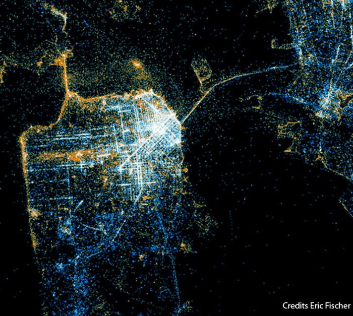
ESRI ArcGIS I: Mapping and Analyzing Urban Information
Date: March 5, 2-9pm
Instructor: Richard M. Kos, AICP
During this workshop session, participants will be introduced to the general applications of ESRI ArcGIS 10 software for the visualization and analysis of digital geospatial data representing complex urban environments. The workshop will teach methods for collecting and organizing a variety of geospatial data sets in order to build a GIS archive. Participants will learn to activate and use the embedded data sets for urban network analysis and Census data analysis. Participants will also be introduced to numerous, free, online GIS data repositories in order to facilitate the creation of customized GIS archives for their own research and design work.

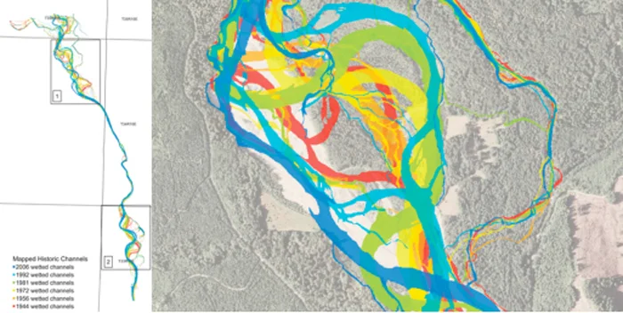
ESRI ArcGIS II: 3D Analyst and ArcScene
Date: March 12, 2-9pm
Instructors: Richard M. Kos, AICP and Mona El Khafif
During this workshop session, participants will be introduced to the ArcGIS 3D Analyst extension that facilitates the display and analysis of terrain and surface data using ArcScene. Users can view a surface from multiple viewpoints, query the attributes of a surface (e.g. elevation, slope), create line-of-sight analyses, and generate realistic perspective images by draping raster and vector data over a surface.

Advanced Illustrator for Urban Ecologies
Date: March 5, 10am-5pm
Instructor: David Fletcher,
Illustrator has become the vector representation tool of choice, for drawing and presenting architectural proposals at all scales. It is used in diagramming, mapping, plan drawing, board layout, and perspectival drawing. It is particularly helpful with regards to urban design and large scale site representation. Students will learn advanced vector representation techniques and tools, which may be applied to plannometric, diagrammatic, sectional, and perspectival representation. Advanced techniques will include action scripting, use of the CADtools plugin, and the use of the Scriptographer plugin. Basic skills covered will include symbol/brush/pattern/swatch creation, use of the blend tool, file transfer, scaling, file and layer management, and layout with multipage. Programs also discussed with relation to interface will include AutoCAD, Photoshop, Sketchup, and ArchGIS. In addition to learning specific tools, we will review and deconstruct various vector plans and drawings to learn how they are done.

FORMATIONS 2010

Event: Mapping Urban Information with ESRI ArcGIS Workshop
Instructors:ARichard Kos, AICPA(CCSF GIS Education Center/ San Jose State University)>Mona El Khafif(CCA California College of the Arts)
Cost:$100 for students, $200 for professionals.
Prerequisites:A basic understanding of ArcGIS 9.3 is recommended, but not required. Participants with prior experience using ArcGIS may be asked to assist other students with in-class assignments as a shared learning experience.

Workshop Description:
During this workshop session participants will be introduced to the general applications of ESRI ArcGIS as a software tool for the collection of digital geospatial data and the analysis of complex urban environments. Geographic Information Systems (GIS)-compatible shapefiles, geodatabases and raster imagery are accessible in diverse online data archives. The workshop will teach methods for collecting and organizing a variety of geospatial data sets in order to build a GIS archive. Participants will learn to activate and use the embedded data sets for urban network analysis and Census data analysis. In the second part of the workshop, we will explore the most commonly-used tools in ArcGIS toolbox in order to identify the tools of interest to architects and urban designers for understanding and exploring the urban environment.

Software:
The class will use ESRI ArcGIS 9.3.1 with extensions. The software runs on PCs, or on Macs possessing a Windows XP, Windows Vista, or Windows 7 partition. A one year student edition of is available for participants without ArcGIS software. Please get in contact with Mona El Khafif melkhafif@cca.edu.

(OP)SPACE

OP_Nave_Small0112.jpg

Project:(OP)space
Date:Spring 2010
Class:A City Space Share
Professor:Mona El Khafif
In Association With: CCA URBANlab

CitySpaceShare is a pilot project being conducted by students and faculty at the CCA URBANlab, an advanced research and design studio supporting project-based initiatives in architecture at California College of the Arts in San Francisco. The goal of the project is to demonstrate how flexible architecture and a Zipcar style short-term rental model can contribute to the cultural and economic development of a neighborhood by giving communities the tools to reclaim unoccupied storefront spaces on a temporary basis.

Downtown San Joses SoFA District was selected as a testing ground for this project because the neighborhood currently suffers from a 40% vacancy rate of street-level storefronts in its commercial core. Working with ZER01, students researched demographics, met with local community members, and proposed a series of flexible architectural prototypes. (OP)space which stands for OPportunities, OPen, and OPerable is the selected design from the broader CitySpaceShare project being tested at the 3rd 01SJ Biennial. The installation is defined by hinging hexagonal sections that operate similarly to the leaves of an expandable table. By shifting the orientation of the sections a wall becomes a table, or a chair becomes a shelf.

(OP)space is installed inside the storefront space of WORKS/San Jose where students are testing their architectural design through a series of programs created with the local community ranging from bike kitchen to fashion show to DJ lounge. During AbsoluteZER0, (OP)space will extend into the street in a structure built specifically to facilitate programming inside the confines of a metered parking spot.

The project is led by Dr. Mona El Khafif, Associate Professor at CCA and project coordinator of URBANlab; Adjunct Professor Kory Bieg; and the following students: Josh Campos, Alexa Getting, Brittany Glover, Richard Lyttle, Carlos Martinez, Jeronimo Roldan, Lauren Tichy, Fabiola Vargas, Mike Vargas, Rachael Yu, and Maryam Zahedi. The CCA URBANlab was founded by the director of CCA Architecture Dr. Ila Berman.

CITY OF THE FUTURE

Project:City of the Future Exhibition and Panel Discussion
Date: Feb 06 2009
Venue:California College of the Arts
Credit: Anderson Anderson Architecture, Fougeron Architects, Gelfand Partners Architects, IF architecture, IwamotoScott Architecture, KUTH/RANIERI Architects, PFAU Architecture

During the last two years, the History Channel, IBM and Infiniti, in partnership with the American Institute of Architects (AIA) and American Society of Civil Engineers (ASCE), have challenged architects and designers nationwide to imagine this countrys most important cities, one hundred years into the future. Last year the selected metropolises were New York, Chicago, and Los Angeles. This years cities were San Francisco, Washington and Atlanta. Eight design firms competed in each city for a $10,000.00 first prize, where the winner of each city was entered into a national competition to be decided by an online vote. This exhibition is of the design proposals of those teams selected to envision the city of San Francisco in the year 2108 a design challenge intensified by the time limit allotted for the development of each teams future urban vision. In the initial event, after having been pre-selected to participate in the competition, each of the teams had only seven days to fully develop their design proposals, three hours to install the exhibition of their work, and 15 minutes to present their ideas to the competition design jury in a public forum held at the Ferry Building on January 20th of this year. IwamotoScott Architecture received the First Place award for their scheme: Hydro Net. Honorable Mentions included two awards: the Infiniti Extraordinary Design Award given to Fougeron Architecture, and the IBM Innovation and Technology Award given to Pfau Architecture.

Exhibition Curation: Mona El Khafif, Mark Donahue
Panel Discussion: Ila Berman, Director of CCA Architecture in discussion with: Fougeron Architecture, Gelfand Partners, IF architecture, IwamotoScott Architecture, KUTH/RANIERI Architects, Anderson Anderson Architecture, PFAU Architecture